a(vc)%C2%A9+(Wild+View+Yonder)+660+x+165.jpg)
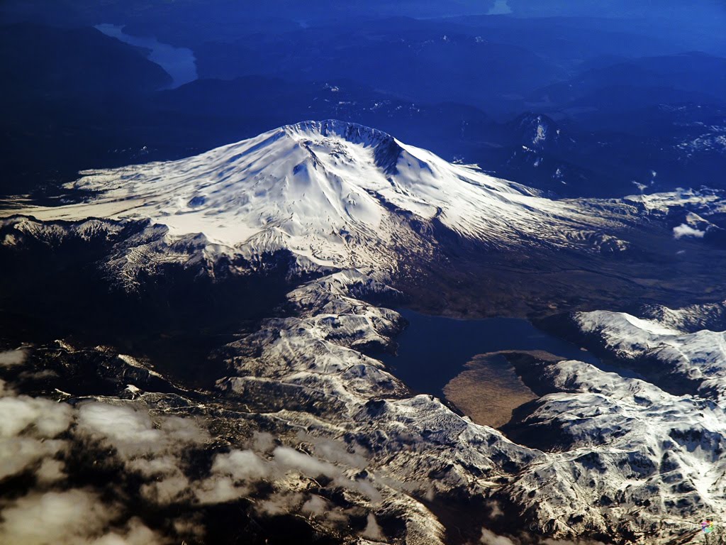
Today, some 30 years on, areas of the park that have been under the stewardship of logging companies have been replanted with thick forests, albeit of far less diversity than would occur naturally. Some large areas of the park have not been artificially replanted. There, the post-eruption conditions have been largely left alone except for restoration of a few roads and installation of several view points and associated parking areas, allowing nature to take its course and heal itself at its own pace, and providing an opportunity to observe, document, and learn from this experience.
Today, much of the blast zone is still fairly barren. Spirit Lake remains full of the logs of trees that were blown down in the eruption, covering about 1/3 of the lake surface, floating back and forth at the whim of the winds. In and around the blast areas though, clear signs are everywhere of life reasserting itself. Within the last 5 years or so, small trees that had emerged between the fallen trunks of their predecessors have begun to grow taller. Birds and other wildlife are increasingly found in these areas. It's not hard to imagine in another 25-30 years, this area will look much as it did before the eruption.
Meanwhile, inside the crater, another kind of growth is going on. The mountain itself is healing. At a rate that has been described as the equivalent of a dump-truck full every few seconds, a dome of ash and lava grows. Most of the time a plume of smoke and steam is visible over the mountain; more noticeable during cooler weather when the steam condenses as it rises. Given enough time, even the mountain will eventually return to a conical shape, leaving little surface evidence of that cataclysmic event.
For an up-close and personal look at the mountain, check out this Gigapan.

July 20, 2010
May 13, 2010

Apr 13, 2010

Sep 9, 2008

July 22, 2008

Jan 1, 2008

Feb 1, 2005

Feb 26, 2008

Feb 26, 2008

Apr 4, 2006

Apr 4, 2006

May 18, 2003

May 25, 2006

May 29, 2007

May 29, 2007

May 29, 2007

Jun 7, 2007: Molokini of the North.
Molokini [Wikipedia]
Molokini Aerial [Maui Boat Rental]

Jun 7, 2007


Jun 7, 2007

Jun 20, 2006

Jun 30, 2005

Jul 3, 2007

Jul 25, 2007

Jul 29, 2005

Sep 8, 2005

Oct 5, 2004

Oct 5, 2004

Oct 5, 2004

Oct 5, 2004

Oct 25, 2005

Nov 17, 2005

Nov 20, 2007

Nov 20, 2007

May 1, 2008

Feb 3, 2009

Right now (View from Johnston Ridge Visitor Center, courtesy USGS).


4 comments:
Breathtaking! And informative as well. Thanks for posting these.
Wow.
Fabulous stuff, Eye.
Thanks for bringing us a truly chronological account of the big lady.
It's surreal yet astoundingly natural to see the great rift filling in over time.
Keep it coming!
Really interesting! It's great to see how its appearance changes over time!
Amazing photography!!! I love photo's from the mountais and the once you show are just breath-taking!
Post a Comment