Thursday, May 7, 2009

Yosemite

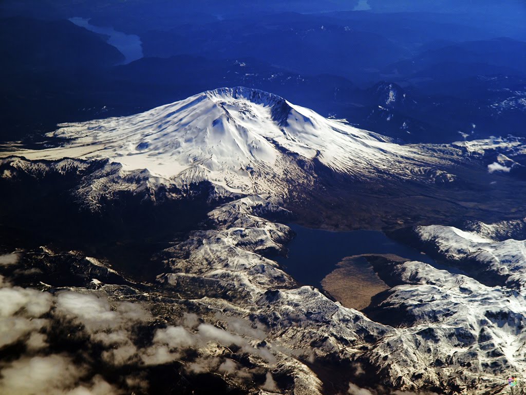
Yosemite National Park is known the world over and really needs no introduction. Thousands of people fly over the park every day but few see it or recognize it if they are looking. Yosemite is quite spectacular from the air, as clearly shown below.


Yosemite valley and El Capitan peeking out from beneath the clouds.


Yosemite Valley, Half Dome at right.


Half Dome at upper right.


Close shot of Half Dome.


Stereogram of Half Dome and vicinity.
Click to enlarge; cross eyes to converge the two images to appear as three.
3-d effect will appear in the middle. Be patient - this gets easier with experience.
(1536px wide version here)


Upper El Capitan brightly illuminated in the late afternoon sunshine. Upper Yosemite Falls can be seen in shadow above and to the right of El Capitan (click to enlarge).


El Capitan stands out in the foreground. To its lower right, and clearly visible during one of the rare times when it's actually illuminated in direct sunshine is Bridal Veil Fall. Half Dome towers over the upper-right corner of the image; below and to its right, in shadow, can be seen Nevada Falls and Vernal Falls. Even Upper Yosemite Falls can be seen (barely visible in shadow) in this shot, up and to the left of El Capitan.
(Click to enlarge)


Wide shot of Yosemite; El Capitan in lower-left quadrant and Half Dome in upper right. The telltale vertical white line of Upper Yosemite Falls can be clearly seen to the upper right of El Capitan. Mono Lake appears in the upper-right corner of the image.


Close shot of El Capitan.
Optical distortion visible at the bottom of the image is caused by the aircraft window.


Yosemite in the summer heat.


Upper Yosemite Falls can just barely be discerned just left of the center of this image.
(click to enlarge)


El Capitan and a good portion of the valley are visible in this view.


Same shot, different day...
Shadows of the late afternoon obscure much of the valley.


Half Dome casts its late afternoon shadow over the trees beyond.


January 2009, El Capitan.


A closer crop of El Capitan.


January 2009, Half Dome.


And a closer crop of Half Dome.


Snow-capped El Capitan peeking out from beneath the clouds.


May 2009, stitched from 4 images. The falls are all in sunlight.


May 2009, more falls in sunlight.

More information about Yosemite National Park [wikipedia].

Monday, September 1, 2008

Above Kauai

An aerial tour of the Hawaiian island of Kauai, the Garden Island on Blue Hawaiian Helicopters.
A few of these images also are featured on Shutter-Eye photoblog.


Leaving Lihue Airport


Over Nawiliwili


Kauai Marriott at lower left


Towards Kipu


Kipu


Looking southwest toward Po
ʻipu


Tunnel of Trees


So Many Falls, So Little Time


Manawaioʻpuna Falls


Toward Waimea Town


Secluded Plantation House

Above Waimea Canyon


Stereogram - click to enlarge; cross eyes to converge the two images to appear as three.


Stereogram - click to enlarge; cross eyes to converge the two images to appear as three.


Pacific Missile Range Radar Tracking and Communications Facility.


Captain Andy's Tour Boats. Note people snorkeling in the water.


Honopu Area


Kalalau Valley


Hanakapiʻai Beach


Hanakapiʻai Beach


Hanakapiʻai Valley and Beach


Keʻe / Tunnels Beach


Keʻe / Tunnels Beach


Lumahaiʻi


Hanalei Valley


Mouth of the Wainiha River with Baily Bridges spanning it


Wainiha Valley


Inside Mt. Waialeale


Waterfall Inside Mt. Waialeale


Agricultural Plantation


Entrance to Lihue Airport

Saturday, March 22, 2008

St. Helens

Mount St. Helens [US Forest Service] Erupted in1980 [Wikipedia], blasting more than a cubic kilometer skyward, obliterating in that moment what had been a pristine wilderness park, turning much of it into a barren moonscape.

Today, more than a quarter of a century later, areas of the park that have been under the stewardship of logging companies have been replanted with thick forests, albeit of far less diversity than would occur naturally. Some large areas of the park have not been artificially replanted. There, the post-eruption conditions have been largely left alone except for restoration of a few roads and installation of several view points and associated parking areas, allowing nature to take its course and heal itself at its own pace, and providing an opportunity to observe, document, and learn from this experience.

Today, much of the blast zone is still fairly barren. Spirit Lake remains full of the logs of trees that were blown down in the eruption, covering about 1/3 of the lake surface, floating back and forth at the whim of the winds. In and around the blast areas though, clear signs are everywhere of life reasserting itself. Within the last 5 years or so, small trees that had emerged between the fallen trunks of their predecessors have begun to grow taller. Birds and other wildlife are increasingly found in these areas. It's not hard to imagine in another 25-30 years, this area will look much as it did before the eruption.

Meanwhile, inside the crater, another kind of growth is going on. The mountain itself is healing. At a rate that has been described as the equivalent of a dump-truck full every few seconds, a dome of ash and lava grows. Most of the time a plume of smoke and steam is visible over the mountain; more noticeable during cooler weather when the steam condenses as it rises. Given enough time, even the mountain will eventually return to a conical shape, leaving little surface evidence of that cataclysmic event.

For an up-close and personal look at the mountain, check out this recent Gigapan.


September 9, 2008


July 22, 2008


Jan 1, 2008


Feb 1, 2005


Feb 26, 2008


Feb 26, 2008


Apr 4, 2006


Apr 4, 2006


May 18, 2003


May 25, 2006


May 29, 2007


May 29, 2007


May 29, 2007


Jun 7, 2007: Molokini of the North.
Molokini [Wikipedia]
Molokini Aerial [Maui Boat Rental]


Jun 7, 2007


Jun 7, 2007


Jun 20, 2006


Jun 30, 2005


Jul 3, 2007


Jul 25, 2007


Jul 29, 2005


Sep 8, 2005


Oct 5, 2004


Oct 5, 2004


Oct 5, 2004


Oct 5, 2004


Oct 25, 2005


Nov 17, 2005


Nov 20, 2007


Nov 20, 2007


May 1, 2008


Feb 3, 2009


Right now (View from Johnston Ridge Visitor Center, courtesy USGS).

Saturday, March 8, 2008

Crater Lake

Welcome to Wild View Yonder. This site is specifically for aerial photography. Some of the images featured here are cross-posted to Shutter-Eye as well. Posts on this site will grow over time as appropriate new images become available.

I chose as the banner image a shot of Crater Lake because it is perhaps one of the most striking aerial Images I have shot to date. It seems fitting therefore that the first post on this site should be a Crater Lake collection. The images featured here were selected from many I've taken over the years. Image quality varies from image to image due to various factors including atmospheric conditions (weather, fires, pollution, etc.), proximity to the subject, altitude, time of day, season, camera equipment, and the condition of the aircraft windows.

Enjoy.


5/22/2008 12:09pm


11/20/2007 7:55am


10/23/2007 2:58pm


10/23/2007 2:58pm


10/23/2007 2:58pm


10/23/2007 2:59pm


10/23/2007 3:01pm


8/7/2007 7:36am


6/30/2005 8:10am


5/29/2007 8:08am


4/2/2007 7:52am


5/19/2006 8:55am


6/26/2004 1:30pm

See Crater Lake from the ground.